

Our next two days at Glacier played out very suitably.
OH! First of all, let me clarify. It is officially the Waterton Glacier International Peace Park.
okay. carry on.
On our first evening, we realized that it was unrealistic to
think we could contain ourselves to explore just one side of the park. Although
the illustrious “Going to the Sun” road was not yet open for a full-length
commute, we learned that a day trip from end to end was easily doable via
highway 2 which weaved itself around the southern borders of the park.
 |
| John Stevens. Roosevelt's monument was just to the left. |
Mother had spotted a description for a 5-hour boat and
hiking tour that started from a southeastern dock in Two Medicine at 11:30.
Naively, we thought that leaving at 9:30 would get us there on time, which also
left plenty of space for a long-awaited Mother-daughter tiff and subsequent
heart-to-heart early in the morning. Yet with our projected two-hour leeway, we
had not accounted for the views that our ogling eyes were prone to stopping for
at every whim. Not to mention the suggested historical markers. We actually
only had to stop in one place for these because the par had sort of decided to
wad a ton of statues and memorial plaques in a historical marker circus at one
spot called Marias Pass, supposedly named after the cousin of Meriwether Lewis.
The pass, known to the Blackfeet indians as “Backbone Pass“ was once the only
route from Mountains to Plaines and used solely by Natives for thousands of
years until 1889 when a man named John F. Stevens found it and earned himself a
monument here. Roosevelt also gets one, of course. Also at the pass, the
mountains displayed a clear view of the effects of the Lewis Overthrust – a
phenomenon that occurred 170 million years ago at the time that the Rockies
lifted and tilted sea beds into mountains and forced older rock to fault and
slide on top of younger material. So
that was a cool thing.
 |
| 72 million years ago when the Rockies formed, Precambrian age sediments were moved from 50 miles away and thrust on top of that lighter layer of younger rock. Below the fault remains Cretaceous shale from 110 million years ago. |
Needless to say, by the time we got to the docks, the boat
we were meant to be on was a distant speck on the lake. But it was a perfect
day to miss a 5 hour hike. And a perfect day to drive over two hours each way.
For it was a day spotted with bouts of rain and wind that forced us into snow coats
and gloves.


There was plenty to admire when the weather forced us into the
warmth of our car and just after we arrived to the east side, the sun came out
long enough for us to enjoy a nature trail to Running Eagle falls named in
honor of a young native woman who sought spirit through a vision quest despite
such endeavors being taken on only by men during her time.


As we returned from
our walk, rain returned andwe ate lunch in our car perched atop a lookout
point, watching the clouds pour down misty blue-grey sheens on the large
ice-striped peaks. As I experienced to be standard protocol when I was in
Yellowstone, many a car pulled up behind us for a minute to see if we were
spotting anything interesting (usually, that means wildlife) before dejectedly
speeding off.

 By the time we emerged from our car for the next walk at
Barring Falls – part of going to the sun road just past St. Mary’s - we were
both so enchanted with the landscape, hopping in and out of the weather to make
roadside stops, that it didn’t seem to matter as much that it was raining
again. Unlike the Old Growth forests we had been in the evening before, this
area dipped down into a semi-open encasement of ferns and shrubs, following
along the embankment of tossing, turning rapid water. It felt like we could
encounter anything and when we encountered some fresh scat…mother started to
chant and sing. After about a mile jaunt and some more breathtaking views, we
safely emerged to the road and trekked back, finally feeling the brutality of
the wind and wet without the trees to protect us. Back at the car, we decided
it was time for another round of indoor recuperations.
By the time we emerged from our car for the next walk at
Barring Falls – part of going to the sun road just past St. Mary’s - we were
both so enchanted with the landscape, hopping in and out of the weather to make
roadside stops, that it didn’t seem to matter as much that it was raining
again. Unlike the Old Growth forests we had been in the evening before, this
area dipped down into a semi-open encasement of ferns and shrubs, following
along the embankment of tossing, turning rapid water. It felt like we could
encounter anything and when we encountered some fresh scat…mother started to
chant and sing. After about a mile jaunt and some more breathtaking views, we
safely emerged to the road and trekked back, finally feeling the brutality of
the wind and wet without the trees to protect us. Back at the car, we decided
it was time for another round of indoor recuperations.


 |
| I just had to put this picture in because it is a range I can name the mountains of. Left to right: Curly Bear, Kakitos, Norris, Split, Red Eagel, Mahtotopa, Little Chief |
As we learned about the Park, some dates struck me. George
Granell, the man largely responsible for Glacier, had lobbied to protect the
land in 1900, officially making Glacier a National Park in 1910. If you recall
the history lesson we had gotten the day before, that is the same year that
Whites were allowed to sweep in and set up homes. The exhibits rode a delicate
balance of embracing the rich history of the park’s development while also
acknowledging the what it took from so many people. They did this by dedicating
one part of the building to an exhibit of each tribe’s traditions, all content
provided by elders of the tribes themselves.
Each had beliefs of why the Rockies were sacred. The Salish
called them ”The Backbone” of the land. The Blackfeet noticed it as a haven for
Animal, Bird and Water Spirits and a space for powerful vision quests. The
Kootenai saw that all physical and spiritual needs were contained in this one,
compact space and hesitantly shared an abridged creation story about three
woodpeckers, the youngest of which was killed by a giant sea monster and so the
elder ones went after it. When it was killed, its body parts made up the
aboriginal territory. But not without the help of a friendly giant who stood
up, hit his head on the sky and died, contributing to the layout.
Each tribe also favored a different animal of the region.
The creation story of the Salish tells of Coyote (Snele) preparing the earth
for the first people. The Blackfeet have a story of a Bear (Pahksi-Kwai) who
taught a young boy the same wisdom that allowed bear to look through a smoked pipe and see the core of a
person’s heart. And the Kootenai had many names for Elk because it was so
important.
It was getting late – we knew because they were patiently
trying to usher us out of the closing visitor’s center – and we still hadn’t
made it to Many Glacier, supposedly the Mecca of the park. We pretty much
booked it there. Except for the dramatic display of fire-bare trees and the
time I thought we were finally seeing a bear…only to discover we were coming up
to Many Glacier through farm country.
 |
| The Busses that they designed for tourists in the 30s still do tours today. |
 |
| We learned later that this was a fire that took down 10% of the region, stretching into the Canadian part of the park |
 |
| Will it clear up for us....? |
 |
| Nah... |
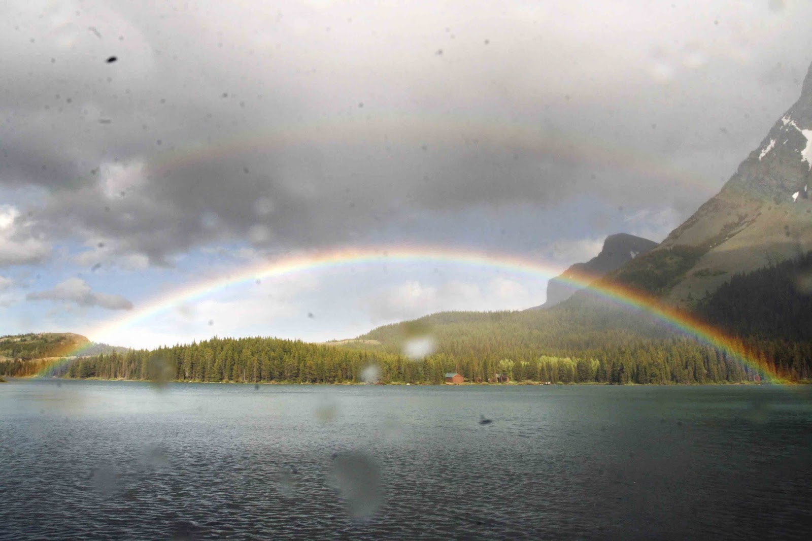
We didn’t do a long hike because we were starting to become very aware of the commute we had before us and I was less than enthusiastic about the thought of stopping at one of the eateries we’d passed, most exclaiming “Ice Cream” or “Pie! Or “great Burger deals!” As we got out of the car one last time, a rainbow appeared before us and as we ventured onto a lakeside trail, we met up with it again, stretching out in a full sweeping arch with another arc beginning to take shape over it. We were pretty content to call it a night at that point. Plus, I saw some cool trees and one looked like a yogi.


Before we started the long drive, mother wanted to step into
the old Many Glacier lodge, one of the first to be put up for tourists of the
park. I admit, I was a lot more impressed than I thought I would be. The old
wood and original signs and doorposts exuding a rugged regal look made me feel
like I was on the Titanic. And there was a Violinist performance to boot. They
also had a poignant photo exhibit in the hallway that juxtaposed old and recent
images of the park’s Glaciers. As we had learned in the visitor’s center, the
land that once boasted 150 Glaciers was now down to about 25 with a projection
that they will be gone by 2020.

 |
| The grizzlies are there, I swear |
Like I said, the rainbow seemed like the gem of the day. But
as I wound us back towards the outer roads, we came to a lookout packed with
quite a few cars. Mother thought it was nothing – just enjoying the view – but
I begged to differ. “This isn’t a nothing kind of stop.” Sure enough, as we
pulled past the first few cars, I turned to see a brown ball moving out in the
grass. “BEAR!” After yelling the false alarm half a dozen times that day, I was
finally able to say it for reals. It was two Grizzlies and they were wrestling!
After that, we were in look out mode, make slow turns and glancing distractedly
out windows. But we didn’t have to glance far. Just after turning a few more
corners, we were stopped in our tracks. There in the middle of the road, a
Black Bear was pacing back and forth in a sort of dizzy trance. As I inched a
little closer (we were giving it plenty of space, promise) Mother made spazzy
remarks like “don’t go closer! You
don’t want to disturb it! I’m so glad we aren’t walking right now!” After
pacing from one side of the road to the other and facing us head on at one
point (which I admit, was a bit intimidating) He slumped down into the woods
and by the time we’d inched up just a few dozen feet to where he had been, he
was nowhere to be seen. “Wow, they disappear pretty fast” I said.
“That’s…creepy.

To avoid some of the winding road back, we took a route that
took us way out into farm lands but rose us up so that we could see the full
range of mountains and the dramatic clouds we had been under all day. Even that
flat grassland was beautiful. Glacier was beautiful. We didn’t even (hardly)
mind not arriving back at the cabin for dinner until 10pm. It was the best tour
we could have ever chosen to miss.


No comments:
Post a Comment